# Map Service REST API
# Introduction
The map service uses REST APIs. Frontend development can use the Service class in the vjmap JS SDK to call the service. To get map metadata, use:
let svc = new vjmap.Service(env.serviceUrl, env.accessToken);
let res = await svc.metadata("sys_zp" /*map id*/, "v1" /*map version, empty for latest*/);
console.log(res)
2
3
When this code runs in the browser, F12 Network shows an http request to the map service.
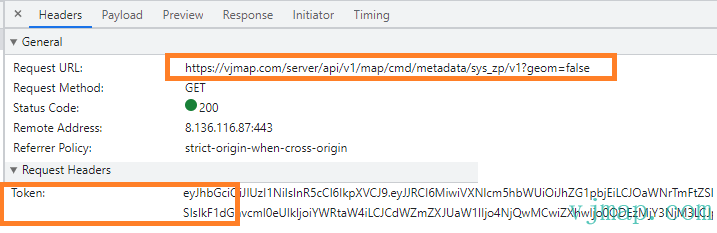
For backend calls, send the same http request.
Test in Postman:
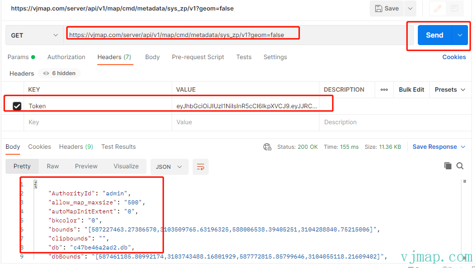
The map service REST API returns correct results when called from Postman.
Note: All service calls must use application/json and include the Token header (or token=xxxx query parameter for GET requests) for authentication. To open password-protected maps without a password prompt, add secretKey or accessKey in the request header. (This is not repeated in examples below; remember to add Token in practice.)
# Common Service APIs
(For brevity, only relative URLs are shown. E.g. https://vjmap.com/server/api/v1/map/cmd/metadata/sys_zp/v1 is abbreviated as /api/v1/map/cmd/metadata/sys_zp/v1)
# Upload Drawing
| Service URL | /api/v1/map/uploads |
| Request Type | Post |
| Request Parameter | Parameter Description | Parameter Example |
|---|---|---|
| fileToUpload | File binary content |
# Create or Open Drawing
| Service URL | /api/v1/map/openmap/{mapid} |
| Request Type | Get or Post |
| Request Parameter | Parameter Description | Parameter Example |
|---|---|---|
| version | Map version | |
| layer | Style | |
| geom | Open with geometry render mode | true |
| fileid | File unique ID. Pass fileid when opening map for first time | cfbe8dc085fb |
| imageLeft | Image top-left x. Valid when opening image type for first time | undefined |
| imageTop | Image top-left y. Valid when opening image type for first time | |
| imageResolution | Image resolution. Valid when opening image type for first time | |
| uploadname | Upload filename | zp.dwg |
| mapfrom | Map source (for collaborative drawings) | |
| mapdependencies | Map dependencies (for collaborative drawings) | |
| subfrom | Map source for sub-items (for collaborative drawings) | |
| subdependencies | Map dependencies for sub-items (for collaborative drawings) | |
| stylename | Style layer name | |
| layeron | Layer indices to turn on, e.g. [0,1,3] | |
| layeroff | Layer indices to turn off, e.g. [2,4] | |
| clipbounds | Map clip bounds, e.g. [x1,y1,x2,y2] | |
| bkcolor | Background color | 0 |
| lineweight | Line weight, e.g. [1,1,1,1,0] | |
| expression | Style expression | |
| secretKey | Set when encrypting map on first creation | |
| accessKey | Access key when map has password |
Note: When setting a password on first upload, set secretKey. Compute as: MD5(MD5(MD5(MD5(password)))), take first 16 chars.
Node.js backend upload and create/open example
// app.js
const fs = require('fs')
const FormData = require('form-data')
const axios = require('axios')
const prompt = require('prompt');

(async ()=>{
    const defaultServiceUrl = 'https://vjmap.com/server/api/v1';
    const defaultAccessToken = 'eyJhbGciOiJIUzI1NiIsInR5cCI6IkpXVCJ9.eyJJRCI6MiwiVXNlcm5hbWUiOiJhZG1pbjEiLCJOaWNrTmFtZSI6ImFkbWluMSIsIkF1dGhvcml0eUlkIjoiYWRtaW4iLCJCdWZmZXJUaW1lIjo4NjQwMCwiZXhwIjo0ODEzMjY3NjM3LCJpc3MiOiJ2am1hcCIsIm5iZiI6MTY1OTY2NjYzN30.cDXCH2ElTzU2sQU36SNHWoTYTAc4wEkVIXmBAIzWh6M';

    let formData = new FormData();
    let { filepath } =  await prompt.get('filepath'); // Enter file path to upload
    if (!filepath) return;
    let file = fs.createReadStream(filepath)
    formData.append('fileToUpload', file);

    let len = await new Promise((resolve, reject) => {
      return formData.getLength((err, length) => (err ? reject(err) : resolve(length)));
    });
    let res = await axios({
        url: `${defaultServiceUrl}/map/uploads?token=${defaultAccessToken}`,
        method: 'POST',
        data: formData,
        headers: {
          ...formData.getHeaders(),
          'Content-Length': len,
        },
    });
    /*
    {
        fileid: 'c036d8ca23eb',
        mapid: 'c036d8ca23eb', // mapid is suggested; if previously uploaded/opened, use that mapid
        uploadname: 'base1.dwg'
    }
    */
    console.log(res.data);

    // Upload sends file to server. On first open, pass fileid to openMap and assign mapid. Afterwards open by mapid.
    let { mapid } =  await prompt.get('mapid'); // Enter mapid
    if (!mapid) {
        // If no mapid, use default from upload response
        mapid = res.data.mapid;
    }
    let url = `${defaultServiceUrl}/map/openmap/${res.data.mapid}?version=&layer=&geom=true&fileid=${res.data.fileid}&uploadname=${res.data.uploadname}&mapfrom=&mapdependencies=&subfrom=&subdependencies=&stylename=&layeron=&layeroff=&clipbounds=&bkcolor=0&lineweight=&expression=`;
    // To set password, e.g. 123456
    //  MD5 four times, strMd5 is MD5 helper, implement as needed
    // let secretKey =  strMd5(strMd5(strMd5(strMd5("123456")))).substr(0, 16);
    // url += "&secretKey=" + secretKey
    let result = await axios({
        url: url,
        method: 'GET',
        headers: {
          token: defaultAccessToken,
        },
    });
    console.log(result)
})();
2
3
4
5
6
7
8
9
10
11
12
13
14
15
16
17
18
19
20
21
22
23
24
25
26
27
28
29
30
31
32
33
34
35
36
37
38
39
40
41
42
43
44
45
46
47
48
49
50
51
52
53
54
55
56
57
58
59
60
To create drawings from parameters in the backend, generate a JSON object from the entity objects, serialize to string (or base64), and pass as fileid.
Node.js parameter-based drawing creation:
const axios = require("axios");


(async () => {
  const defaultServiceUrl = "https://vjmap.com/server/api/v1";
  const defaultAccessToken =
    "eyJhbGciOiJIUzI1NiIsInR5cCI6IkpXVCJ9.eyJJRCI6MiwiVXNlcm5hbWUiOiJhZG1pbjEiLCJOaWNrTmFtZSI6ImFkbWluMSIsIkF1dGhvcml0eUlkIjoiYWRtaW4iLCJCdWZmZXJUaW1lIjo4NjQwMCwiZXhwIjo0ODEzMjY3NjM3LCJpc3MiOiJ2am1hcCIsIm5iZiI6MTY1OTY2NjYzN30.cDXCH2ElTzU2sQU36SNHWoTYTAc4wEkVIXmBAIzWh6M";

  let doc = {};
  let entitys = [];
  // See official docs https://vjmap.com/doc/Class_DbDocument.html for parameters
  entitys.push({
    typename: "DbLine",
    start: [14, 0],
    end: [14, 15],
    colorIndex: 1,
  });
  entitys.push({
    typename: "DbCircle",
    center: [14, 7.5],
    radius: 1.83,
    color: 0xff0000,
  });
  entitys.push({
    typename: "DbText",
    position: [14, 16],
    contents: "Basketball court diagram",
    colorIndex: 1,
    horizontalMode: 4,
    height: 1,
  });
  doc.entitys = entitys;

  // Base64 encoding also works but not recommended; JSON string is fine
  //var bytes = new Buffer(JSON.stringify(doc));
  //var base64 = "data:application/dwg;base64," + bytes.toString('base64')// let fileid = base64;

    let fileid = JSON.stringify(doc);
  // Upload sends file to server. On first open, pass fileid to openMap and assign mapid. Afterwards open by mapid.
  let mapid = "mybackendmap"
  let url = `${defaultServiceUrl}/map/updatemap/${mapid}`;
  let data = {
    fileid: fileid,
    clipbounds: '',
    bkcolor: 0,
    geom: true,
    uploadname: ""
  }
  // To set password (e.g. 123456): MD5 four times; implement strMd5 as needed
  // let secretKey =  strMd5(strMd5(strMd5(strMd5("123456")))).substr(0, 16);
  // url += "&secretKey=" + secretKey
  let result = await axios({
    url: url,
    method: "POST",
    headers: {
      token: defaultAccessToken,
    },
    data
  });
  console.log(result);
})();
2
3
4
5
6
7
8
9
10
11
12
13
14
15
16
17
18
19
20
21
22
23
24
25
26
27
28
29
30
31
32
33
34
35
36
37
38
39
40
41
42
43
44
45
46
47
48
49
50
51
52
53
54
55
56
57
58
59
60
61
62
63
Result:
# Check If File Already Uploaded
| Service URL | api/v1/map/mapfile |
| Request Type | Get |
| Service Description | Check if file exists on server before upload; if so return fileid without uploading. Can be skipped in practice. |
| Request Parameter | Parameter Description | Parameter Example |
|---|---|---|
| md5 | File MD5 value | fbe8dc085fbcdac502c640cf2dd8065c |
Node.js implementation for file MD5 (other backends can adapt):
import SparkMD5 = require("spark-md5");
/**
     * Get file MD5 value
     * @param file
     * @return {Promise<any>}
     */
    function fileMd5(file: File): Promise<any> {
        return new Promise((resolve, reject) => {
            const blobSlice =
                // @ts-ignore
                File.prototype.slice || File.prototype.mozSlice || File.prototype.webkitSlice;
            const chunkSize = 2097152; // Read in chunks of 2MB
            const chunks = Math.ceil(file.size / chunkSize);
            let currentChunk = 0;
            const spark = new SparkMD5.ArrayBuffer();
            const fileReader = new FileReader();

            fileReader.onload = function(e) {
                // @ts-ignore
                spark.append(e.target.result); // Append array buffer
                currentChunk++;

                if (currentChunk < chunks) {
                    loadNext();
                } else {
                    var md5 = spark.end();
                    resolve(md5);
                }
            };

            fileReader.onerror = function() {
                reject("file reader error");
            };

            function loadNext() {
                var start = currentChunk * chunkSize;
                var end = start + chunkSize >= file.size ? file.size : start + chunkSize;
                fileReader.readAsArrayBuffer(blobSlice.call(file, start, end));
            }

            loadNext();
        });
    }
2
3
4
5
6
7
8
9
10
11
12
13
14
15
16
17
18
19
20
21
22
23
24
25
26
27
28
29
30
31
32
33
34
35
36
37
38
39
40
41
42
43
# Update Drawing
| Service URL | /api/v1/map/updatemap/{mapid} |
| Request Type | Get or Post |
Same parameters as Create or Open Drawing
# Raster Tile URL
| Service URL | api/v1/map/tile/{mapid}/{version}/{stylename}/{zoom}/{x}/{y} |
| Request Type | Get |
| Service Description | mapid: map id; version: version; stylename: style name; zoom: level; x,y: tile column/row |
| Request Parameter | Parameter Description | Parameter Example |
|---|---|---|
| tag | fileid |
# Vector Tile URL
| Service URL | api/v1/map/tile/{mapid}/{version}/{stylename}/{zoom}/{x}/{y}.mvt |
| Request Type | Get |
| Service Description | mapid: map id; version: version; stylename: style name; zoom: level; x,y: tile column/row |
| Request Parameter | Parameter Description | Parameter Example |
|---|---|---|
| tag | fileid |
# Execute Map Command
| Service URL | api/v1/map/cmd/${cmdname}/${mapid}/${version} |
| Request Type | Get or Post |
| Service Description | cmdname: command name; mapid: map id; version: version |
| Request Parameter | Parameter Description | Parameter Example |
|---|---|---|
| Parameters vary by command name |
# Get Map Metadata
| Service URL | api/v1/map/cmd/metadata/${mapid}/${version} |
| Request Type | Get or Post |
| Service Description | mapid: map id; version: version |
| Request Parameter | Parameter Description | Parameter Example |
|---|---|---|
| geom | Whether geometry rendering |
# Update Map Metadata
| Service URL | api/v1/map/cmd/updateMetadata/${mapid}/${version} |
| Request Type | Get or Post |
| Service Description | mapid: map id; version: version |
| Request Parameter | Parameter Description | Parameter Example |
|---|---|---|
| Metadata key | Value for the metadata key |
# Proactively Close Open Map
| Service URL | api/v1/map/cmd/closemap/${mapid}/${version} |
| Request Type | Get or Post |
| Service Description | mapid: map id; version: version |
| Request Parameter | Parameter Description | Parameter Example |
|---|---|---|
| (none) | (none) |
# Get Map List
| Service URL | api/v1/map/cmd/listmaps/${mapid}/${version} |
| Request Type | Get or Post |
| Service Description | mapid: map id (empty = get all); pass map ID array to get specified maps; use pagination e.g. {curPage: 1, pageCount: 10}; version: version (empty = latest, * = all versions) |
| Request Parameter | Parameter Description | Parameter Example |
|---|---|---|
| mapIds | When mapid is empty, specify map ID array to query |
# Query Entities
| Service URL | api/v1/map/cmd/queryFeatures/${mapid}/${version} |
| Request Type | Get or Post |
| Service Description | mapid: map id; version: version |
| Request Parameter | Parameter Description | Parameter Example |
|---|---|---|
| querytype | Query type: "condition", "rect", "point", "expresion" | condition |
| beginpos | Record start position | 0 |
| bounds | Bounds | "" |
| condition | Query condition | layerindex = 0 |
| fields | Comma-separated field list to return, e.g. "name,objectid" | |
| geom | Whether geometry query | true |
| includegeom | Return geometry: when realgeom is false, if count>1 returns bounding rect per entity, if count=1 returns real GeoJSON; when realgeom is true returns GeoJSON per entity | true |
| isContains | Contain vs intersect: true=contain, false=intersect (default false). Used when bounds is set | false |
| layername | Style name (required). Use stylename from createMapStyle, e.g. api/v1/map/cmd/createMapStyle/yourMapid/v1?geom=true&token=xxx | |
| maxReturnCount | Max records to return | 50000 |
| realgeom | Return real entity geometry GeoJSON. Used with includegeom | true |
| expr | Expression | |
| x | Point query x | |
| y | Point query y | |
| pixelsize | Point query pixel size | |
| zoom | Current zoom level | 1 |
| toMapCoordinate | By default query returns Mercator; result is converted to CAD. Set true to return CAD coordinates directly. |
Relevant SDK query source in JS:
/**
 * Query entity parameters
 */
export interface IQueryBaseFeatures {
    /** Current zoom level. */
    zoom?: number;
    /** Map ID (empty = current map). */
    mapid?: string;
    /** Map version (empty = current). */
    version?: string;
    /** Layer name (empty = current map layer). */
    layer?: string;
    /** Max records to return. */
    limit?: number;
    /** Comma-separated field list to return, e.g. "name,objectid" */
    fields?: string;
    /** Whether geometry query. */
    geom?: boolean;
    /** GeoJSON simplify tolerance in Mercator; 0 = no simplify. */
    simplifyTolerance?: boolean;
    /** Enable cache (for in-memory maps). */
    useCache?: boolean;
    /** By default returns Mercator; set true to return CAD coordinates. */
    toMapCoordinate?: boolean;
}

/**
 * Point query entity parameters
 */
export interface IPointQueryFeatures extends IQueryBaseFeatures {
    /** Query X. */
    x: number;
    /** Query Y. */
    y: number;
    /** Pixel size. */
    pixelsize?: number;
    /** Condition. */
    condition?: string;
    /** Max geometry bytes to return. */
    maxGeomBytesSize?: number;
    /** Geo length per pixel; if set, overrides zoom-based calculation. */
    pixelToGeoLength?: number;
}

/**
 * Rect query entity parameters
 */
export interface IRectQueryFeatures extends IQueryBaseFeatures {
    /** X1 (omit x1,y1,x2,y2 to query full map). */
    x1?: number;
    /** Y1. */
    y1?: number;
    /** X2. */
    x2?: number;
    /** Y2. */
    y2?: number;
    /** Condition. */
    condition?: string;
    /** Max geometry bytes to return. */
    maxGeomBytesSize?: number;
}

/**
 * Expression query entity parameters
 */
export interface IExprQueryFeatures extends IQueryBaseFeatures {
    /** Expression. */
    expr: string;
    /** Record start position. */
    beginpos?: number;
}

/**
 * Condition query entity parameters
 */
export interface IConditionQueryFeatures extends IQueryBaseFeatures {
    /** Condition. */
    condition: string;
    /** Bounds. */
    bounds?: [number,number,number,number];
    /** Record start position. */
    beginpos?: number;
    /** Include geometry; when realgeom false, multiple results get bbox only, single gets GeoJSON; when realgeom true each gets GeoJSON. */
    includegeom?: boolean;
    /** Return real entity GeoJSON; used with includegeom. */
    realgeom?: boolean;
    /** Contain (true) vs intersect (false) when bounds set; default false. */
    isContains?: boolean;
}
    /**
     * Point query entities
     * @param param Parameters
     * @param cb Callback for each point in result; null = default handling
     */
    async pointQueryFeature(param: IPointQueryFeatures, cb?: (point: [number, number]) => [number, number] | null | undefined): Promise<any> {
        const res = await this.execCommand(
            "queryFeatures",
            {
                querytype: "point",
                zoom: param.zoom ?? 1,
                pixelToGeoLength: param.pixelToGeoLength ?? undefined,
                layername: param?.layer ?? this._cur_map_param?.layer,
                x: param.x,
                y: param.y,
                pixelsize: param.pixelsize ?? 5,
                condition: param.condition ?? undefined,
                maxReturnCount: param.limit ?? undefined,
                maxGeomBytesSize: param.maxGeomBytesSize ?? undefined,
                fields: param.fields ?? "",
                geom: param.geom ?? undefined,
                simplifyTolerance: param.simplifyTolerance ?? undefined,
                useCache: param.useCache,
                toMapCoordinate: param.toMapCoordinate,
            },
            param.mapid,
            param.version
        );
        return this._processQueryResult(res, cb);
    }

    /**
     * Rect query entities
     * @param param Parameters
     * @param cb Callback for each point; null = default handling
     */
    async rectQueryFeature(param: IRectQueryFeatures, cb?: (point: [number, number]) => [number, number] | null | undefined): Promise<any> {
        const res = await this.execCommand(
            "queryFeatures",
            {
                querytype: "rect",
                zoom: param.zoom ?? 1,
                layername: param?.layer ?? this._cur_map_param?.layer,
                x1: param.x1,
                y1: param.y1,
                x2: param.x2,
                y2: param.y2,
                condition: param.condition ?? undefined,
                maxReturnCount: param.limit ?? undefined,
                maxGeomBytesSize: param.maxGeomBytesSize ?? undefined,
                fields: param.fields ?? "",
                geom: param.geom ?? undefined,
                simplifyTolerance: param.simplifyTolerance ?? undefined,
                useCache: param.useCache,
                toMapCoordinate: param.toMapCoordinate,
            },
            param.mapid,
            param.version
        );
        return this._processQueryResult(res, cb);
    }

    /**
     * Expression query entities
     * @param param Parameters
     * @param cb Callback for each point; null = default handling
     */
    async exprQueryFeature(param: IExprQueryFeatures, cb?: (point: [number, number]) => [number, number] | null | undefined): Promise<any> {
        const res = await this.execCommand(
            "queryFeatures",
            {
                querytype: "expresion",
                zoom: param.zoom ?? 1,
                layername: param?.layer ?? this._cur_map_param?.layer,
                expr: param.expr,
                beginpos: param.beginpos,
                maxReturnCount: param.limit ?? undefined,
                limit: param.limit ?? undefined,
                fields: param.fields ?? "",
                useCache: param.useCache ?? false,
                geom: param.geom ?? undefined,
                simplifyTolerance: param.simplifyTolerance ?? undefined,
                toMapCoordinate: param.toMapCoordinate,
            },
            param.mapid,
            param.version
        );
        return this._processQueryResult(res, cb);
    }

    /**
     * Condition query entities
     * @param param Parameters
     * @param cb Callback for each point; null = default handling
     */
    async conditionQueryFeature(param: IConditionQueryFeatures, cb?: (point: [number, number]) => [number, number] | null | undefined): Promise<any> {
        const res = await this.execCommand(
            "queryFeatures",
            {
                querytype: "condition",
                zoom: param.zoom ?? 1,
                layername: param?.layer ?? this._cur_map_param?.layer,
                condition: param.condition,
                beginpos: param.beginpos,
                maxReturnCount: param.limit ?? undefined,
                limit: param.limit ?? undefined,
                includegeom: param.includegeom ?? undefined,
                realgeom: param.realgeom ?? undefined,
                isContains: param.isContains ?? undefined,
                fields: param.fields ?? "",
                bounds: param.bounds ? JSON.stringify(param.bounds) : "",
                geom: param.geom ?? undefined,
                simplifyTolerance: param.simplifyTolerance ?? undefined,
                useCache: param.useCache,
                toMapCoordinate: param.toMapCoordinate,
            },
            param.mapid,
            param.version
        );
        return this._processQueryResult(res, cb);
    }

// _processQueryResult converts returned Mercator coordinates to CAD coordinates. For backend queries returning CAD coordinates directly, set toMapCoordinate to true.
2
3
4
5
6
7
8
9
10
11
12
13
14
15
16
17
18
19
20
21
22
23
24
25
26
27
28
29
30
31
32
33
34
35
36
37
38
39
40
41
42
43
44
45
46
47
48
49
50
51
52
53
54
55
56
57
58
59
60
61
62
63
64
65
66
67
68
69
70
71
72
73
74
75
76
77
78
79
80
81
82
83
84
85
86
87
88
89
90
91
92
93
94
95
96
97
98
99
100
101
102
103
104
105
106
107
108
109
110
111
112
113
114
115
116
117
118
119
120
121
122
123
124
125
126
127
128
129
130
131
132
133
134
135
136
137
138
139
140
141
142
143
144
145
146
147
148
149
150
151
152
153
154
155
156
157
158
159
160
161
162
163
164
165
166
167
168
169
170
171
172
173
174
175
176
177
178
179
180
181
182
183
184
185
186
187
188
189
190
191
192
193
194
195
196
197
198
199
200
201
202
203
204
205
206
207
208
209
210
211
212
213
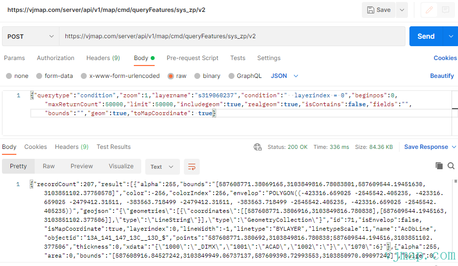
You can also inspect request parameters via the visual interface:
https://vjmap.com/app/visual/#/query?mapid=sys_zp&version=v1&mapopenway=GeomRender&theme=dark (opens new window) (Replace sys_zp with your mapid)
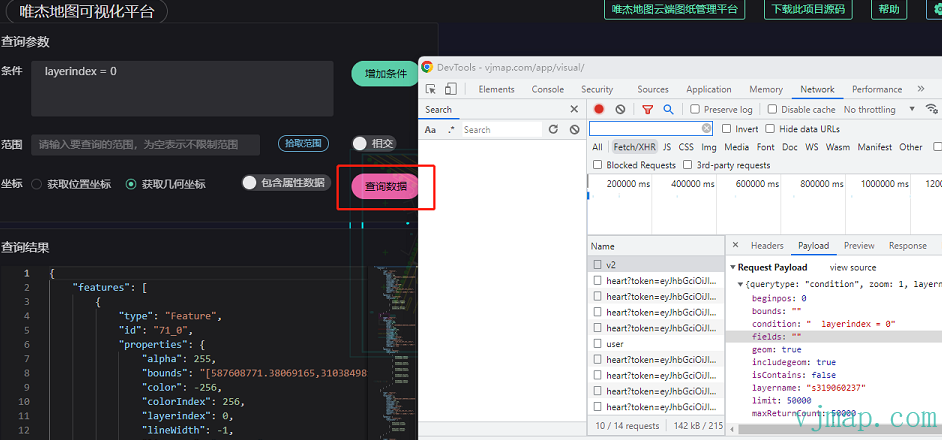
When testing in Postman, set toMapCoordinate to true to return CAD coordinates directly.
# Switch Layer
| Service URL | api/v1/map/cmd/switchlayer/${mapid}/${version} |
| Request Type | Get or Post |
| Service Description | mapid: map id; version: version |
| Request Parameter | Parameter Description | Parameter Example |
|---|---|---|
| visibleLayers | Array of visible layer indices | |
| darkMode | Whether dark theme |
# Get Style Layer Name
| Service URL | api/v1/map/cmd/createMapStyle/${mapid}/${version} |
| Request Type | Get or Post |
| Service Description | mapid: map id; version: version |
| Request Parameter | Parameter Description | Parameter Example |
|---|---|---|
| geom | Whether geometry rendering | |
| name | Style name | |
| layeron | Layer indices to turn on, e.g. [0,1,3] | |
| layeroff | Layer indices to turn off, e.g. [2,4]. Use either layeron or layeroff | |
| clipbounds | Map clip bounds [x1,y1,x2,y2]. Single number = scale factor | |
| backcolor | Background color | |
| lineweight | Line weight [1,1,1,1,0]: levels 1–4 on, level 5 off; empty = same as original | |
| expression | Expression |
# Get Data Bounds of Drawing
| Service URL | api/v1/map/cmd/getDataBounds/${mapid}/${version} |
| Request Type | Get or Post |
| Service Description | mapid: map id; version: version |
| Request Parameter | Parameter Description | Parameter Example |
|---|---|---|
| (none) |
# Get Map Thumbnail
| Service URL | api/v1/map/cmd/thumbnail/${mapid}/${version} |
| Request Type | Get or Post |
| Service Description | mapid: map id; version: version |
| Request Parameter | Parameter Description | Parameter Example |
|---|---|---|
| width | Width in pixels | |
| height | Height in pixels | |
| darkTheme | Dark theme; if true, image is inverted (black to white) |
# WMS Tile URL
| Service URL | api/v1/map/cmd/wms/${mapid}/${version} |
| Request Type | Get or Post |
| Service Description | mapid: map id; version: version |
| Request Parameter | Parameter Description | Parameter Example |
|---|---|---|
| layers | Layer name (empty = current map layer). | |
| bbox | Bounds, default {bbox-epsg-3857}. For CAD extent without conversion, use CAD bounds and leave srs, crs, mapbounds empty. | |
| srs | Current CRS, default EPSG:3857 | |
| crs | CAD map CRS; empty = from metadata. Can be proj4 string | |
| mapbounds | Geographic bounds; when set, srs is ignored | |
| width | Tile width in pixels | |
| height | Tile height in pixels | |
| transparent | Background when opaque; default white. Must be rgb(r,g,b) or rgba(r,g,b,a), a=255 for opaque. | |
| backgroundColor | Background color when not transparent | |
| fourParameter | Four-parameter (x offset, y offset, scale, rotation in radians), optional | |
| isInverseFourParamter | Use inverse of four-parameter, default false | |
| mvt | Whether vector tiles | |
| useImageRotate | Consider rotation for CRS conversion. Default auto | |
| imageProcessAlg | Image processing for rotation: 1 or 2, default auto | |
| webMapType | Web base map type: WGS84 (e.g. Tianditu, OSM), GCJ02 (e.g. Amap, Tencent), BD09LL/Bd09MC (Baidu) |
JS source:
/**
 * WMS service URL parameters
 */
export interface IWmsTileUrl {
    /** Map ID (empty = current); array = request multiple. */
    mapid?: string | string[];
    /** Map version (empty = current). */
    version?: string | string[];
    /** Layer name (empty = current map layer). */
    layers?: string | string[];
    /** Bounds, default {bbox-epsg-3857}. For CAD extent without conversion use CAD bounds and leave srs, crs, mapbounds empty. */
    bbox?: string;
    /** Current CRS, default EPSG:3857. */
    srs?: string;
    /** CAD map CRS; empty = from metadata. Can be proj4 string. */
    crs?: string | string[];
    /** Geographic bounds; when set, srs is ignored. */
    mapbounds?: string;
    /** Width. */
    width?: number;
    /** Height. */
    height?: number;
    /** Transparent. */
    transparent?: boolean;
    /** Background when opaque; default white. rgb(r,g,b) or rgba(r,g,b,a), a=255 for opaque. */
    backgroundColor?: string;
    /** Four-parameter (x, y offset, scale, rotation rad), optional. */
    fourParameter?: string | string[];
    /** Use inverse four-parameter, default false. */
    isInverseFourParamter?:  boolean | boolean[];
    /** Vector tiles. */
    mvt?: boolean;
    /** Consider rotation for CRS conversion; default auto. */
    useImageRotate?: boolean;
    /** Image processing for rotation: 1 or 2, default auto. */
    imageProcessAlg?: number;
    /** Web base map type: WGS84, GCJ02, BD09LL, BD09MC. */
    webMapType?: "WGS84" | "GCJ02" | "BD09LL" | "BD09MC"
}
    wmsTileUrl(param: IWmsTileUrl): string {
        const mapid = param.mapid ?? this._cur_map_param?.mapid;
        const version = param.version ?? ((param.mapid == this._cur_map_param?.mapid) ? this._cur_map_param?.version : "_") ?? "_";
        const layers = param.layers ?? this._cur_map_param?.layer;
        const bbox = param.bbox ?? "{bbox-epsg-3857}";
        const srs = param.srs ?? "EPSG:3857";// base map CRS
        let crs = param.crs ?? ""; // CAD map CRS
        if (crs.indexOf("+") >= 0) {
            // proj4 string
            // @ts-ignore
            crs = encodeURIComponent(crs);
        }
        const mapbounds = param.mapbounds ?? "";
        const width = param.width ?? 256;
        const height = param.height ?? 256;
        const transparent = param.transparent ?? true;
        const fourParameter = param.fourParameter ?? "";
        const isInverseFourParamter = param.isInverseFourParamter === true ? `&isInverseFourParamter=true` : "";
        const mvt = param.mvt === true ? ".mvt" : ""
        const useImageRotate = param.useImageRotate === true ? `&useImageRotate=true` : "";
        const imageProcessAlg = isNumber(param.imageProcessAlg) ? `&imageProcessAlg=${param.imageProcessAlg}` : "";
        const webMapType = param.webMapType ? `&webMapType=${param.webMapType}` : "";
        const backgroundColor = (param.backgroundColor && !transparent) ? `&backgroundColor=${param.backgroundColor}` : "";
        if (!Array.isArray(mapid)) {
            // Single map WMS request
            return  `${this._url("cmd")}/wms/${mapid}/${version}${mvt}` +
                `?mapbounds=${mapbounds}${bbox ? "&bbox=": ""}${bbox}&format=image/png&service=WMS&request=GetMap&srs=${srs}&transparent=${transparent}&width=${width}&height=${height}&layers=${layers}&crs=${crs}&fourParameter=${fourParameter}${isInverseFourParamter}${useImageRotate}${imageProcessAlg}${webMapType}${backgroundColor}&token=${this.accessToken}`
        } else {
            // Multiple maps WMS request
            //&layers=${layers}&crs=${crs}&fourParameter=${fourParameter}
            //${mapid}/${version}
            let mapidArr = mapid;
            let versionArr = Array.isArray(version) && version.length == mapidArr.length ?  version : mapidArr.map(m => version ?? "_")
            let layersArr = Array.isArray(layers) && layers.length == mapidArr.length ?  layers : mapidArr.map(m => layers ?? "")
            let crsArr = Array.isArray(crs) && crs.length == mapidArr.length ?  crs : mapidArr.map(m => crs ?? "")
            let fourParameterArr = Array.isArray(fourParameter) && fourParameter.length == mapidArr.length ?  fourParameter : mapidArr.map(m => fourParameter ?? "")
            let isInverseFourParamterArr = Array.isArray(isInverseFourParamter) && isInverseFourParamter.length == mapidArr.length ?  isInverseFourParamter : mapidArr.map(m => isInverseFourParamter ?? "")
            let param = `bbox=${bbox}&mapbounds=${mapbounds}&format=image/png&service=WMS&request=GetMap&srs=${srs}&transparent=${transparent}&width=${width}&height=${height}`
            let arrayParam = `mapid=${mapidArr.join("_,")}&version=${versionArr.join("_,")}&layers=${layersArr.join("_,")}&crs=${crsArr.join("_,")}&fourParameter=${fourParameterArr.join("_,")}&isInverseFourParamter=${isInverseFourParamterArr.join("_,")}`
            if (mapidArr.length == 1) {
               return `${this._url("cmd")}/wms/${mapidArr[0]}/${versionArr[0]}${mvt}` +
                    `?mapbounds=${mapbounds}${bbox ? "&bbox=": ""}${bbox}&format=image/png&service=WMS&request=GetMap&srs=${srs}&transparent=${transparent}&width=${width}&height=${height}&layers=${layersArr[0]}&crs=${crsArr[0]}&fourParameter=${fourParameterArr[0]}&isInverseFourParamter=${isInverseFourParamterArr[0]}${useImageRotate}${imageProcessAlg}${webMapType}${backgroundColor}&token=${this.accessToken}`
            } else {
                return `${this._svr_url_service}wms?${param}&${arrayParam}${useImageRotate}${imageProcessAlg}${webMapType}${backgroundColor}&token=${this.accessToken}`;
            }
        }
    }
2
3
4
5
6
7
8
9
10
11
12
13
14
15
16
17
18
19
20
21
22
23
24
25
26
27
28
29
30
31
32
33
34
35
36
37
38
39
40
41
42
43
44
45
46
47
48
49
50
51
52
53
54
55
56
57
58
59
60
61
62
63
64
65
66
67
68
69
70
71
72
73
74
75
76
77
78
79
80
81
82
83
84
85
86
87
# Delete Map
| Service URL | api/v1/map/cmd/deletemap/${mapid}/${version} |
| Request Type | Get or Post |
| Service Description | mapid: map id; version: version; use "*" to delete all versions |
| Request Parameter | Parameter Description | Parameter Example |
|---|---|---|
| retainVersionMaxCount | When deleting all versions, keep this many latest (e.g. 10 versions, 3 = keep latest 3) |
# Rename Map
| Service URL | api/v1/map/cmd/deletemap/${mapid}/_ |
| Request Type | Get or Post |
| Service Description | mapid: map id |
| Request Parameter | Parameter Description | Parameter Example |
|---|---|---|
| newMapId | New map id |
# Clear Map Geometry and Tile Cache
| Service URL | api/v1/map/cmd/clearCacheTiles/${mapid}/${version} |
| Request Type | Get or Post |
| Service Description | mapid: map id; version: version |
| Request Parameter | Parameter Description | Parameter Example |
|---|---|---|
| (none) |
# Clear Map Tile Cache
| Service URL | api/v1/map/cmd/clearCacheStyles/${mapid}/${version} |
| Request Type | Get or Post |
| Service Description | mapid: map id; version: version |
| Request Parameter | Parameter Description | Parameter Example |
|---|---|---|
| (none) |
# Delete Map Style
| Service URL | api/v1/map/cmd/deletestyle/${mapid}/${version} |
| Request Type | Get or Post |
| Service Description | mapid: map id; version: version |
| Request Parameter | Parameter Description | Parameter Example |
|---|---|---|
| styleid | Style id | |
| onlycleardata | Only clear data |
# Delete Map Cache
| Service URL | api/v1/map/cmd/deletecache/${mapid}/${version} |
| Request Type | Get or Post |
| Service Description | mapid: map id; version: version |
| Request Parameter | Parameter Description | Parameter Example |
|---|---|---|
| key | Cache key prefix |
# Get System Run Status
| Service URL | api/v1/map/cmd/runstatus/${mapid}/${version} |
| Request Type | Get or Post |
| Service Description | mapid: map id; version: version |
| Request Parameter | Parameter Description | Parameter Example |
|---|---|---|
| detail | Whether to return detailed data |
# Compose New Map
| Service URL | api/v1/map/cmd/composeNewMap/_null/v1 |
| Request Type | Get or Post |
| Service Description |
| Request Parameter | Parameter Description | Parameter Example |
|---|---|---|
| mapid | Map ID | |
| version | Map version | |
| clipbounds | Map clip bounds [x1,y1,x2,y2]; empty = no clip | |
| selByCrossing | Contain vs intersect (default false = contain, true = intersect) | |
| fourParameter | Four-parameter (x, y offset, scale, rotation rad), optional | |
| isInverseFourParamter | Use inverse four-parameter, default false | |
| layers | Layer names to show; empty = all | |
| layerPrefix | Layer name prefix for new map | |
| layerSuffix | Layer name suffix for new map | |
| savefilename | Output filename; empty = auto from params | |
| purge | Purge after compose to reduce DWG size | |
| cadVersion | Export CAD version; * = current |
JS source:
/**
 * Compose new map parameters
 */
export interface IComposeNewMap {
    /** Map ID. */
    mapid: string;
    /** Map version (empty = current). */
    version?: string;
    /** Clip bounds [x1,y1,x2,y2]; empty = no clip. */
    clipbounds?: [number, number, number, number];
    /** Contain (false) vs intersect (true). */
    selByCrossing?: boolean;
    /** Four-parameter (x, y offset, scale, rotation rad), optional. */
    fourParameter?:  [number, number, number, number];
    /** Use inverse four-parameter, default false. */
    isInverseFourParamter?:  boolean;
    /** Layer names to show; empty = all. */
    layers?: string[];
    /** Layer name prefix for new map. */
    layerPrefix?: string;
    /** Layer name suffix for new map. */
    layerSuffix?: string;
    /** Output filename; empty = auto from params. */
    savefilename?: string;
    /** Purge after compose to reduce DWG size. */
    purge?: boolean
    /** Export CAD version; * = current. */
    cadVersion?: string | "*" | "cad2000" | "cad2004" | "cad2007" | "cad2010" | "cad2013"| "cad2018"
}

    /**
     * Compose new map
     * @param param Compose parameters
     * @return {Promise<any>}
     */
    async composeNewMap(param: IComposeNewMap | IComposeNewMap[]) {
        if (!Array.isArray(param)) {
            param = [param] // normalize to array
        }
        let cmdParam: Record<string, any> = {};
        if (param.length > 1) {
            cmdParam['count'] = param.length;
        }

        for(let i = 0; i < param.length; i++) {
            let paramKey = i === 0 ? "" : ((i + 1) + "")
            cmdParam['mapid' + paramKey] = param[i].mapid;
            cmdParam['version' + paramKey] = param[i].version;
            cmdParam['clipBounds' + paramKey] = Array.isArray(param[i].clipbounds) ? JSON.stringify(param[i].clipbounds) : undefined;
            cmdParam['selByCrossing' + paramKey] = param[i].selByCrossing;
            cmdParam['fourParameter' + paramKey] = Array.isArray(param[i].fourParameter) ? JSON.stringify(param[i].fourParameter) : undefined;
            cmdParam['isInverseFourParamter' + paramKey] = param[i].isInverseFourParamter === true ? true : undefined;
            cmdParam['layers' + paramKey] = Array.isArray(param[i].layers) ? JSON.stringify(param[i].layers) : undefined;
            cmdParam['layerPrefix' + paramKey] = param[i].layerPrefix;
            cmdParam['layerSuffix' + paramKey] = param[i].layerSuffix;
            cmdParam['savefilename' + paramKey] = param[i].savefilename;
            cmdParam['purge' + paramKey] = param[i].purge;
            if (param[i].cadVersion) {
                cmdParam['cadVersion' + paramKey] = param[i].cadVersion;
            }
        }
        return await this.execCommand("composeNewMap", cmdParam, "_null", "v1", false);
    }
2
3
4
5
6
7
8
9
10
11
12
13
14
15
16
17
18
19
20
21
22
23
24
25
26
27
28
29
30
31
32
33
34
35
36
37
38
39
40
41
42
43
44
45
46
47
48
49
50
51
52
53
54
55
56
57
58
59
60
61
62
63
64
# Projection PRJ WKT to Proj4 String
| Service URL | api/v1/map/cmd/prjWktToPrj4Str// |
| Request Type | Post |
| Service Description | Convert PRJ WKT to proj4 string. |
| Request Parameter | Parameter Description | Parameter Example |
|---|---|---|
| wkt | PRJ file WKT string |
# Export Layout to DWG
| Service URL | api/v1/map/cmd/exportLayout/_null/v1 |
| Request Type | Get or Post |
| Service Description | mapid: map id; version: version |
| Request Parameter | Parameter Description | Parameter Example |
|---|---|---|
| mapid | Map ID | |
| version | Map version (empty = current) | |
| layoutIndex | Layout index; use either layoutIndex or layoutName, layoutIndex takes precedence. Both empty = current DWG layout. | |
| layoutName | Layout name. Use either layoutIndex or layoutName. Both empty = current DWG layout. |
# Object Match
| Service URL | api/v1/map/cmd/objectMatch/_null/v1 |
| Request Type | Get or Post |
| Service Description |
| Request Parameter | Parameter Description | Parameter Example |
|---|---|---|
| mapid | Map ID | |
| version | Map version (empty = current) | |
| layer | Style layer name; empty = determined by selected entities | |
| mapBounds | Match extent; default full map | |
| objectIds | Entity objectId array, separated by || | |
| objectBounds | Entity bounds | |
| layeron | Layers to turn on for match | |
| size | Image size for match, default 10000 | |
| method | "matchTemplate" or "matchPattern" | |
| maxCount | Score threshold (0–1), default 0.6 | |
| minReduceArea | Pyramid size (64–2048), default 256; for matchPattern | |
| canOverlap | Allow overlap (default false) | |
| maxOverlap | Overlap ratio (0–0.8), default 0.3 | |
| toleranceAngle | Angle range (-180, 180) for rotation; for matchPattern, default 180 | |
| useToleranceRange | Use angle range (default false); for matchPattern | |
| tolerance1 | Angle range 1 start; for matchPattern | |
| tolerance2 | Angle range 1 end; for matchPattern | |
| tolerance3 | Angle range 2 start; for matchPattern | |
| tolerance4 | Angle range 2 end; for matchPattern |
# Get Created Entity Geometry Data
| Service URL | api/v1/map/cmd/createEntityGeoData/_null/v1 |
| Request Type | Get or Post |
| Service Description |
| Request Parameter | Parameter Description | Parameter Example |
|---|---|---|
| filedoc | File document | |
| mapBounds | Drawing bounds; empty = full map | |
| renderAccuracy | Render accuracy, default 1. Increase if circles/arcs are not smooth (clears cache and may increase file size and hurt performance) | |
| excludeAttribute | Exclude attributes from result (default true) | |
| useZip | Use zip compression for result (default true) |
# Get All Workspaces
| Service URL | api/v1/service/getWorkspace |
| Request Type | Get |
| Service Description |
# Workspace Switch
The request URLs above are for the default workspace.
To use a different workspace, change the path prefix:
Replace /api/v1/map/ with /api/v1/workspace/{workspaceName}/
Example: upload URL /api/v1/map/uploads for workspace w1 becomes /api/v1/workspace/w1/uploads
Frontend code to switch workspace:
/**
* Switch to workspace
* @param workspaceName Workspace name
* @return
*/
function  switchWorkspace(workspaceName) {
    workspaceName = workspaceName.trim()
    this._workspaceName = workspaceName;
    if (workspaceName != "") {
        // specified workspace
        this._svr_url_map = this.serverUrl + "workspace/" + workspaceName + "/";
    } else {
        // default workspace
        this._svr_url_map = this.serverUrl + "map/";
    }
}
2
3
4
5
6
7
8
9
10
11
12
13
14
15
16
# Full-Text Search API
# Add Single Document
| Service URL | /api/v1/service/fullsearch/add |
| Request Type | Post |
| Request Parameter | Parameter Description | Parameter Example |
|---|---|---|
| document | Document with fields: id, map_ver, content, type (1:single-line text, 2:multiline, 3:attribute, 4:block attribute, 5:layer, 6:block name, 7:linetype, 8:hatch, 9:custom), min_x, min_y, max_x, max_y, props (JSON), create_time, workspace, data |
# Batch Add Documents
| Service URL | /api/v1/service/fullsearch/batchAdd |
| Request Type | Post |
| Request Parameter | Parameter Description | Parameter Example |
|---|---|---|
| documents | Document list; each has same fields as document above |
# Update Document
| Service URL | /api/v1/service/fullsearch/update |
| Request Type | Put |
| Request Parameter | Parameter Description | Parameter Example |
|---|---|---|
| document | Document with fields: id, map_ver, content, type (1:single-line text, 2:multiline, 3:attribute, 4:block attribute, 5:layer, 6:block name, 7:linetype, 8:hatch, 9:custom), min_x, min_y, max_x, max_y, props (JSON), create_time, workspace, data |
# Delete Document
| Service URL | /api/v1/service/fullsearch/delete |
| Request Type | Delete |
| Request Parameter | Parameter Description | Parameter Example |
|---|---|---|
| id | Document ID |
# Delete Documents by Map Version
| Service URL | /api/v1/service/fullsearch/deleteByMapver |
| Request Type | Delete |
| Request Parameter | Parameter Description | Parameter Example |
|---|---|---|
| map_ver | Map version | |
| workspace | Workspace name |
# Batch Delete Documents
| Service URL | /api/v1/service/fullsearch/batchDelete |
| Request Type | Post |
| Request Parameter | Parameter Description | Parameter Example |
|---|---|---|
| ids | Document ID array | |
| query | Query condition | |
| map_ver | Map version | |
| workspace | Workspace | |
| type | Document type | |
| bounding_box | Bounding box [minX, minY, maxX, maxY] | |
| time_range | Time range |
# Delete Documents by ID Prefix
| Service URL | /api/v1/service/fullsearch/deleteByIDPrefix |
| Request Type | Delete |
| Request Parameter | Parameter Description | Parameter Example |
|---|---|---|
| id_prefix | ID prefix |
# Search Documents
| Service URL | /api/v1/service/fullsearch/search |
| Request Type | Get or Post |
| Request Parameter | Parameter Description | Parameter Example |
|---|---|---|
| query | Search keyword | |
| map_ver | Map version (optional, comma-separated e.g. map1,map2_v2) | |
| workspace | Workspace (optional, comma-separated; use * for all) | |
| type | Document type (optional: single, multiple, range e.g. 1,2,5 or 1-3) | |
| bounding_box | Bounding box (optional, "minX,minY,maxX,maxY") | |
| time_range | Time range (optional, "start~end" or N days) | |
| limit | Results per page | |
| offset | Pagination offset | |
| fields | Return fields (comma-separated) | |
| facet | Aggregate MapVer (true/1 to enable) |
# Get Document Count
| Service URL | /api/v1/service/fullsearch/count |
| Request Type | Get |
# Manually Trigger Data Sync
| Service URL | /api/v1/service/fullsearch/sync |
| Request Type | Get |
# Get Workspace Index Status
| Service URL | /api/v1/service/fullsearch/workspaceStatus |
| Request Type | Get |
| Request Parameter | Parameter Description | Parameter Example |
|---|---|---|
| workspace | Workspace name |
# Get Search Suggestions
| Service URL | /api/v1/service/fullsearch/suggestions |
| Request Type | Get |
| Request Parameter | Parameter Description | Parameter Example |
|---|---|---|
| prefix | Search prefix | |
| map_ver | Map version | |
| workspace | Workspace | |
| type | Document type | |
| limit | Max suggestions |
# Search Documents by ID Prefix
| Service URL | /api/v1/service/fullsearch/searchByIDPrefix |
| Request Type | Get or Post |
| Request Parameter | Parameter Description | Parameter Example |
|---|---|---|
| id_prefix | ID prefix | |
| map_ver | Map version (optional) | |
| workspace | Workspace (optional) | |
| limit | Page size | |
| offset | Offset | |
| fields | Return fields (comma-separated) |
# Recognizer API
# Get Recognizer Config List
| Service URL | /api/v1/service/recognizer/list |
| Request Type | Get |
| Service Description | Get all saved recognizer configs |
| Request Parameter | Parameter Description | Parameter Example |
|---|---|---|
| (none) |
# Delete Recognizer Config
| Service URL | /api/v1/service/recognizer/delete |
| Request Type | Delete |
| Service Description | Delete specified recognizer config file |
| Request Parameter | Parameter Description | Parameter Example |
|---|---|---|
| filename | Config file name prefix | config_20231201_001 |
# Add Recognizer Config
| Service URL | /api/v1/service/recognizer/add |
| Request Type | Post |
| Service Description | Save new recognizer config |
| Request Parameter | Parameter Description | Parameter Example |
|---|---|---|
| name | Config name | My recognizer config |
| sameColor | Entities must have same color | true |
| sameLayer | Entities must be on same layer | false |
| sameTextContent | Text content must match | false |
| thumbnail | Thumbnail base64 (optional) | data:image/png;base64,... |
| global | Global match rules | {...} |
| rules | Recognizer rules array | [...] |
# Get Recognizer Config Detail
| Service URL | /api/v1/service/recognizer/detail |
| Request Type | Get |
| Service Description | Get recognizer config details |
| Request Parameter | Parameter Description | Parameter Example |
|---|---|---|
| filenames | Config filenames, comma-separated | config_20231201_001,config_20231201_002 |
# Run Object Recognition
| Service URL | /api/v1/map/cmd/objectDetection/_null/v1 |
| Request Type | Get or Post |
| Service Description | Run smart object recognition on map; identify similar entities by config pattern |
| Request Parameter | Parameter Description | Parameter Example |
|---|---|---|
| mapid | Map ID | sys_zp |
| version | Map version | v1 |
| layer | Style layer name | default |
| pattern | Pattern config JSON | {"name":"test","sameColor":true,"rules":[...]} |
| patternList | Array of pattern configs (alternative to pattern) | ["{"name":"config1",...}","{"name":"config2",...}"] |
| detailedLog | Output detailed match info | false |
| bounds | Recognition bounds, GeoBounds string | -1000,-1000,1000,1000 |
# Drawing Analysis API
# Extract Center Lines
| Service URL | /api/v1/map/cmd/extractCenterLines/_null/v1 |
| Request Type | Get or Post |
| Service Description | Extract center lines from parallel segments; for pipelines, roads, etc. |
| Request Parameter | Parameter Description | Parameter Example |
|---|---|---|
| mapid | Map ID | sys_zp |
| version | Map version | v1 |
| layer | Style layer name | default |
| geom | Geometry rendering | true |
| bounds | Extract bounds, coords or polygon | -1000,-1000,1000,1000 |
| isContains | Contain (true) vs intersect (false) | false |
| minSpaceDistance | Min distance array, comma-separated | 2.5,5.0 |
| maxSpaceDistance | Max distance array, comma-separated | 7.5,15.0 |
| collinearTolerance | Collinear tolerance | 1.0 |
| duplicateTolerance | Duplicate point tolerance | 0.2 |
| maxGapDistance | Max gap to connect segments | 15 |
| numDecimalDigits | Decimal places | 3 |
| minDlMinRatio | Min overlap ratio for double lines | 0.01 |
| paralleSlopeAngleTolerance | Parallel slope angle tolerance (degrees) | 1.5 |
| mergeSlopeAngleTolerance | Merge center line slope tolerance (degrees) | 20 |
| maxCenterMergeDistance | Max distance to merge center segments | 15 |
| minCenterDistance | Min center segment distance | 5.1 |
| bConnectGrapLine | Connect lines within gap | true |
| bMergeNode | Merge endpoints | true |
| bFilterShortLine | Filter lines shorter than min distance | true |
| bMergeLine | Merge connected lines | true |
| bSaveParalleLineJson | Output parallel line coords | false |
| bCenterGeoJson | Return center line as GeoJSON | false |
| bExtractLines | Output extracted line coords | false |
# Map Entity Compare
| Service URL | /api/v1/map/cmd/mapCompare/_null/v1 |
| Request Type | Get or Post |
| Service Description | Compare entities between two map versions; returns added, deleted, modified lists |
| Request Parameter | Parameter Description | Parameter Example |
|---|---|---|
| mapid1 | First map ID | sys_zp |
| version1 | First map version | v1 |
| mapid2 | Second map ID | sys_zp |
| version2 | Second map version | v2 |
# Map Pixel Compare
| Service URL | api/v1/map/cmd/mapDiff/_null/v1 |
| Request Type | Get or Post |
| Service Description | Compare two maps by pixel |
| Request Parameter | Parameter Description | Parameter Example |
|---|---|---|
| mapid1 | Map 1 ID | |
| version1 | Map 1 version (empty = current) | |
| layer1 | Map 1 style layer | |
| mapid2 | Map 2 ID | |
| version2 | Map 2 version (empty = current) | |
| layer2 | Map 2 style layer | |
| noCompareNew | Do not compare new parts | |
| noCompareDelete | Do not compare deleted parts | |
| size | Compare size | |
| cellsize | Cell size | |
| diffMinAlpha | Min diff pixel alpha | |
| diffMinAlpha | Min diff transparency | |
| diffMinColor | Min diff color |
# Map Similarity Analysis
| Service URL | /api/v1/map/cmd/imageSimilarity/_null/v1 |
| Request Type | Get or Post |
| Service Description | Analyze similarity between map and others; returns map IDs sorted by similarity |
| Request Parameter | Parameter Description | Parameter Example |
|---|---|---|
| mapid | Reference map ID | sys_zp |
| version | Reference map version | v1 |