# 样式规范
样式规范是定义地图视觉外观的文档:绘制哪些数据,绘制顺序以及绘制数据时如何设置数据样式。
一个样式有以下根属性:
- 描述信息:
version,metadata - 地图状态:
center,bearing,pitch - 地图要素:
sources,layers - 其他:
sprite,glyphs,light,transition
{
  'version': number, // 版本号
  'name': 'string', // 样式名称
  'sprite': 'string', // 雪碧图
  'glyphs': '***/{fontstack}/{range}.pbf', // 字体
  'sources': {}, // 数据源
  'layers': [] // 图层
}
2
3
4
5
6
7
8
# 数据源
sources
数据源类型由 type 指定,并且必须是 vector, raster, raster-dem, geojson, image, video 之一。
提示
另外,还有一个 canvas 类型,是 image 的扩展:CanvasSource
# vector
使用 vector 数据源的图层必须指定 source-layer 。
'sources': {
  '{source-id}': {
    'type': 'vector',
    'tiles': [
      'http://a.example.com/tiles/{z}/{x}/{y}.pbf'
    ],
    'bounds': [-180, -85.051129, 180, 85.051129]
  },
  '{source-id}': {
    'type': 'vector',
    'url': 'http://api.example.com/tilejson.json'
  },
  '{source-id}', {
    'type': 'vector',
    'url': 'xxx'
  },
}
2
3
4
5
6
7
8
9
10
11
12
13
14
15
16
17
# raster
'sources': {
  '{source-id}': {
    'type': 'raster',
    'tiles': [
      'http://xxx&x={x}&y={y}&l={z}&tk={key}',
      'http://xxx&x={x}&y={y}&l={z}&tk={key}'
    ],
    'tileSize': 256
  },
}
2
3
4
5
6
7
8
9
10
# raster-dem
栅格 DEM 数据源,可使用 rio-rgbify (opens new window) 生成。
# fill no data
gdalwarp -t_srs EPSG:3857 -dstnodata None -co TILED=YES -co COMPRESS=DEFLATE -co BIGTIFF=IF_NEEDED E:\xxx.tif  E:\xxxx.tif

# conver to rgb
rio rgbify -b -10000 -i 0.1 E:\xxxx.tif E:\test\xxx.tif
2
3
4
5
# geojson
GeoJSON 数据源,必须提供 data 属性。可设置 cluster, filter 等。
'sources': {
  // inline GeoJSON
  'geojson-marker': {
    'type': 'geojson',
    'data': {
      'type': 'Feature',
      'geometry': {
        'type': 'Point',
        'coordinates': [-77.0323, 38.9131]
      },
      'properties': {
        'title': 'xxx',
        'marker-symbol': 'monument'
      }
    }
  },
  // url
  'geojson-lines': {
    'type': 'geojson',
    'data': './lines.geojson'
  }
}
2
3
4
5
6
7
8
9
10
11
12
13
14
15
16
17
18
19
20
21
22
# image & video
见数据/栅格。
# GeoServer
# TMS
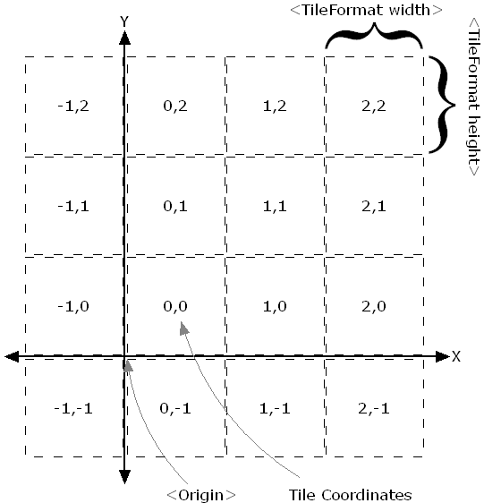
Tile Map Service(瓦片地图服务),简称 TMS。TMS 的切片坐标系统和组织方式可参考下图:
在加载 TMS 服务时,需要设置 scheme 属性为 tms。scheme 属性影响瓦片坐标 y 轴的方向。scheme 有两个值可选:xyz(默认)和 tms。其中 xyz 代表常用的切片规则,即 OGC 标准,切片源点在左上角。tms 是 OSGeo 标准,切片源点是左下角。
加载示例:
// 矢量
'source-id': {
  'type': 'vector',
  'tiles': [
    'https://xxx@pbf/{z}/{x}/{y}.pbf'
  ],
  'scheme': 'tms'
}
// 栅格
'source-id': {
  'type': 'raster',
  'tiles': [
    'https://xxx@png/{z}/{x}/{y}.png'
  ],
  'tileSize': 256,
  'scheme': 'tms'
}
2
3
4
5
6
7
8
9
10
11
12
13
14
15
16
17
# WMS
Web Map Service(Web 地图服务),简称 WMS。WMS 标准定义了允许用户通过 HTTP 对空间数据进行渲染出图等操作。WMS 服务中包括以下3个操作:
- GetCapabilities(获取服务中的要素类及支持的操作)
- GetMap(获取地图)
- GetFeatureInfo(根据地图上的像素点获取更详细的要素信息,类似Identify功能)
利用 GetMap 操作和指定地图边框范围(bbox)和输出格式(format)即可使用。
加载示例(image/png 格式):
'source-id': {
  'type': 'raster',
  'tiles': [
    'https://xxx?service=WMS&version=1.3.0&request=GetMap&layers=china:bj&bbox={bbox-epsg-3857}&width=512&height=512&srs=EPSG:3857&format=image/png&TRANSPARENT=TRUE'
  ]
}
2
3
4
5
6
注意url中的 bbox 参数值 "{bbox-epsg-3857}"。地图会自动计算地图范围替换该值,获取地图。这也是与下面WMTS同样用栅格格式,WMS不会模糊的原因。
# WMTS
Web Map Tile Service(Web地图瓦片服务),简称 WMTS。WMTS 标准定义了一些操作允许用户访问瓦片地图。WMTS 服务中包括以下 3 个操作:
- GetCapabilities(获取服务的元信息)
- GetTile(获取切片)
- GetFeatureInfo(可选,获取点选的要素信息)
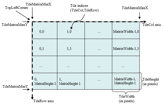
WMTS的切片坐标系统和组织方式可参考下图:
利用 GetTile 操作和指定输出格式即可在中使用。
加载示例(image/png格式):
'source-id': {
  'type': 'raster',
  'tiles': [
    'https://xxx/service/wmts?REQUEST=GetTile&SERVICE=WMTS&VERSION=1.0.0&LAYER=buildings:Chongqing&STYLE=&TILEMATRIX=EPSG:900913:{z}&TILEMATRIXSET=EPSG:900913&FORMAT=image/png&TILECOL={x}&TILEROW={y}'
    // 或 geoserver rest 服务
    // 'https:/xxx/wmts/rest/buildings:Chongqing/EPSG:900913/EPSG:900913:{z}/{y}/{x}?format=image/png'
  ]
}
2
3
4
5
6
7
8
注意
这种方式请求栅格格式(如 image/png)数据会有些模糊,设置 'tileSize': 256 会好很多。但是实际 WMTS 请求返回的图片格式是清晰的。模糊的原因是地图的缩放是无极缩放,也就是 zoom 可以是小数,而 WMTS 的 z 值是整数,在渲染过程中有缩放,所以模糊了。
前面提到加载 wms 也不会模糊,但是 wms 实际上是根据请求范围实时渲染,加载速度不如瓦片服务。
加载示例
'source-id': {
  'type': 'vector',
  'tiles': [
    // geoserver rest 服务
    // 'https://xxx/wmts/rest/buildings:Chongqing/EPSG:900913/EPSG:900913:{z}/{y}/{x}
  ]
}
2
3
4
5
6
7
# WFS
Web Feature Service(Web 要素服务),简称 WFS。WFS 标准定义了一些操作允许用户通过 HTTP 对空间数据进行查询、编辑等操作。WFS 服务中常用的操作包括:
- GetCapabilities(获取服务中的要素类及支持的操作)
- DescribeFeatureType(描述要素类的信息)
- GetFeature(获取要素)
- Transaction(创建、更新、删除数据的事务操作)
利用 GetFeature 操作和指定输出格式即可在使用。
加载示例(application/json 格式):
'source-id': {
  'type': 'geojson',
  'data': `https://xxx?service=WFS&version=2.0.0&request=GetFeature&typeName=buildings:cq_point&outputFormat=application/json`
}
2
3
4
提示
- wfs会请求全部数据,不适用于大量数据。但是支持空间查询和属性查询,也会经常用到。
- 文档:wfs/wms filter (opens new window)
# 图层
layers
图层属性配置如下:
| 属性 | 类型 | 必须 | 描述 |
|---|---|---|---|
id | string | 是 | 图层唯一标识 |
type | string | 是 | 图层类型 |
source | string | 否 | 数据源名称,图层类型除 background 外必须 |
source-layer | string | 否 | 图层名,矢量瓦片源(vector)必须,其他类型不可用 |
minzoom | number | 否 | 图层最小缩放级别 |
maxzoom | number | 否 | 图层最大缩放级别 |
filter | expression | 否 | 过滤器 |
layout | object | 否 | 图层布局属性 |
paint | object | 否 | 图层绘制属性 |
metadata | any | 否 | 任意属性,对跟踪图层很有用,不影响渲染 |
图层示例:
'layers': [
  {
    'id': 'road',
    'type': 'line',
    'source': 'your source',
    'source-layer': 'road',
    'minzoom': 7,
    'maxzoom': 18,
    'layout': {
      'visibility': 'visible'
    },
    'paint': {
      'line-color': 'hsl(55, 1%, 20%)'
    },
    'filter': ['==', '$type', 'LineString']
    'metadata': {
      'type': 'base'
    }
  }
]
2
3
4
5
6
7
8
9
10
11
12
13
14
15
16
17
18
19
20
提示
"type"属性必须是background,fill,line,symbol,raster,circle,fill-extrusion,heatmap,hillshade之一。- 除
background外的图层都需要引用一个源(source),图层从源获取数据、过滤要素和渲染。 layout属性都有visibility属性,可设置"visible"(默认) 和"none"。- 颜色支持
十六进制,RGB,RGBA,HSL,HSLA,HTML 预定义颜色名称格式。
# 表达式
更详细的介绍请参考:expressions
任何 layout 属性、paint 属性或 filter 的值都可以是表达式。示例:
{
  "circle-radius": [
    "interpolate", ["linear"], ["zoom"],
    // when zoom is 0, set each feature's circle radius to the value of its "rating" property
    0, ["get", "rating"],
    // when zoom is 10, set each feature's circle radius to four times the value of its "rating" property
    10, ["*", 4, ["get", "rating"]]
  ]
}
2
3
4
5
6
7
8
9
注意
在表达式中, layout 属性和 paint 属性有一个很重要的区别。paint 属性,只要缩放级别发生变化,都会重新计算 paint 属性,即使是小数变化,比如在 4.1 - 4.6 之间。而 layout 属性只在整数缩放级别时计算,在 4.1 - 4.6 之间不会发生变化,只有在高于 5 或小于 4 时计算。
# Types
表达式拥有强大的类型系统,并支持转换和检测。比如,表达式的输入和输出数据类型需和样式规范中的类型一致,在计算表达式时会自动检测,如果检测到错误,会在控制台输出错误提示。
# Feature data
- feature-state:要素状态,要素状态不是数据的某一属性,需要对通过要素
id设置,如给要素设置hover状态:map.setFeatureState({source: 'states', id: hoveredStateId}, {hover: false}),然后在表达式中即可使用:['feature-state', 'hover']
# Lookup
- get:获取要素属性,如获取
name属性:['get', 'name']
# Decision
在表达式中,可使用常用的条件逻辑,比如:"if/then/else" 的逻辑可使用 'case' 表达式,如需将输入的特定值映射不同的输出,可使用 'match' 表达式。
# Ramps, scales, curves
- interpolate:插值,支持
linear、exponential和cubic-bezier - step:分段
# Variable binding
- let 绑定变量
- var 引用
let绑定的变量
# String
- downcase
- upcase
# Color
- rgb
- rgba
# Math
支持基本的数学运算,如
['/', ['get', 'gdp'], 1000]
# Zoom
获取当前缩放级别,仅用于 step 或 interpolate 表达式的输入。
['zoom']: number
{
      "id": "road",
      "type": "line",
      "source": "a",
      "paint": {
        "line-width": 10,
        "line-pattern": [
          "step", ["zoom"],
          "generic_icon", /*小于2级时用这个线型符号*/
          2,
          "generic_metro" /*大小或等于2级时用这个线型符号*/
        ]
      }
    }
2
3
4
5
6
7
8
9
10
11
12
13
14
# Heatmap
获取热力图图层中像素的核密度估计,只能用于 heatmap-color 属性。
['heatmap-density']: number
更详细的介绍请样式表达式请参考:expressions